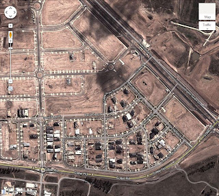
Here are two aerial pictures of Wright. The first before any development and the second I guess would have been around November 2011 (zzomed in to Cotter Rd). Waiting for Google to update their satellite view for once the houses are up.
Here is a photo sourced from the Molonglo Valley website of an aerial view of Wright in June 2012. If you look closely you can see my untouched block with my western and northern neighbours well under way.
Update in mid-November 2012, I realised that Google have updated their satellite view of Wright. In this photo you can see that the frames of the house are up.


No comments:
Post a Comment